

The Caspian Sea is confronting an ecological disaster, with recent years showing a rapid trend of shallowing. While the receding waters affect all Caspian littoral states—Azerbaijan, Russia, Kazakhstan, Iran, and Turkmenistan—Kazakhstan and Azerbaijan are suffering the most. As a result, these two countries have expressed serious concern over the drying of the Caspian Sea.
Impact of the Caspian Sea’s shallowing on oil and gas production and shipping
In addition to severe environmental problems, the retreat of the Caspian Sea is having a significant impact on tourism, oil and gas production, industry, shipping, and logistics.
For quite some time now, alarm bells have been ringing in Kazakhstan regarding the situation, both at the state level and in the media.
The country’s Prime Minister, Olzhas Bektenov, stated that with the decline in the Caspian Sea’s water level beginning in the early 2000s, the Caspian Research Institute of Kazakhstan was established to study this and other related issues. The Prime Minister said that scientists’ forecasts are pessimistic: “To protect this unique body of water, determined and coordinated action by all Caspian littoral states is needed.”
For several years now, the Kazakhstani media has been publishing a series of articles and investigations about the shallowing of the Caspian Sea and the consequences it brings.
The Kazakhstani media states that the shallowing of the Caspian negatively affects all five Caspian littoral countries, but Kazakhstan suffers the most.
This is explained by the fact that, as a result of the shallowing, the northern part of the Caspian Sea may become unusable for oil extraction and shipping.
The Caspian faces Aral syndrome
In recent years, the drop in the water level of the Caspian Sea and the changes observed in its ecosystem have been assessed by regional scientists and ecologists as a process of serious concern. They are also referring to it as the Aral Syndrome. As is known, in the second half of the 20th century, 90% of the Aral Sea dried up, resulting in the formation of a desert in its place.
With the formation of the desert known as Aralkum, an anthropogenic-natural ecological disaster is unfolding in the region. According to scientists' calculations, the impact of anthropogenic factors on the Aral Sea's level decline is more than 70%. The development of agriculture in the Aral region, primarily the expansion of cotton cultivation in irrigated areas, led to a sharp decline in the sea level. Until the 1960s, the entire water reserves of the Amu Darya and Syr Darya rivers — which fed the Aral Sea — were diverted to irrigate agricultural lands. Numerous reservoirs and canals disrupted the balance between water supply and evaporation. In 1985–1986, the sea level dropped from 53 meters to 41 meters, the Berg Strait dried up, and the Aral split into two reservoirs — the Large and Small Aral reservoirs. By 2002, the water level had dropped another 10 meters, and in 2006, the deep water part of the Large Aral Sea — the former Tsche-Bas Gulf — became separated. Between 1960 and 2009, the area of the Aral Sea shrank from 67,499 km² to 6,700 km².
The same syndrome is now being experienced with the Caspian Sea. Although global warming and other environmental factors are cited among the reasons for the Caspian’s shallowing, it is proven with facts that the root of the problem lies in anthropogenic factors. The main factor is the sharp decrease in the volume of water released from the Volga River — the Caspian’s primary source of inflow — into the sea. This tendency has been ongoing for several years now, and the current outcome is clearly visible.
Why has the volume of water flowing from the Volga River into the Caspian sharply decreased?
The shallowing of the Caspian Sea is now clearly evident not only in statistical indicators and satellite images but also in field observations. Alongside natural factors such as global warming and decreased precipitation, on-site observations reveal that anthropogenic impacts play a decisive role in this process.
Notes and observations from an APA correspondent on site suggest a significant reduction in water levels at the mouth of the Volga River. Observations show that in the section of the Volga flowing into the Caspian Sea, the water flow has weakened sharply, leading to shallowing. As a result, the soil layer has emerged, some streams have narrowed into small channels, and others have completely dried up.
The drop in water level at the source of the Volga also negatively affects the area's flora and fauna; aquatic plants are destroyed, and conditions for the survival and reproduction of animals become unbearable. Observations and research show that the main reason for the sharp decrease in the amount of water flowing into the Caspian is the rapid expansion of agricultural lands in the areas along the Volga and the constant maintenance of reservoirs filled with water.
Many reservoirs, dams, and irrigation facilities have been built in the Volga basin.
While these structures make it possible to manage water (water distribution, energy production, irrigation), they negatively impact the volume of water flowing into the sea.
There are also extensive agricultural areas in the Volga basin, and irrigation is required for farming.
It is also worth noting that all the reservoirs were built during the former USSR era. The technical capabilities, water storage capacity, and the likelihood of water leakage from the reservoirs, which have been in operation for many years, should not be overlooked.
The increase in settlements along the Volga also plays a significant role in the process of water reduction.
Another serious factor is the inefficient use of water, both in households and in agriculture.
The volume of water flowing from the Volga into the Caspian has decreased by 30-35 billion cubic meters annually
Satellite observations and analyses carried out by the Space Agency of the Republic of Azerbaijan — "Azercosmos" — show that the volume of water flowing from the Volga River, the main water source of the Caspian, is decreasing year by year, which causes the sea to shallow rapidly.
In October of this year, Azercosmos assessed the dynamics of changes in the water balance of the Volga River basin through satellite monitoring.
The Volga, Europe’s longest river, together with other rivers such as the Kama and Oka, forms the basin of the same name and provides approximately 80 percent of the Caspian Sea’s water resources. Recently, the decline in the Caspian Sea level has been linked not only to climate change but also to human activities in the Volga basin. According to Azercosmos’ research, the average annual water flow in the Volga River is decreasing, and as a result of this process, approximately 30-35 billion cubic meters less water enters the Caspian each year.
The decrease in the volume of water flowing from the Volga River into the Caspian Sea is not only related to climate but is also directly connected to human economic activity. Research shows that there are two main factors behind this process.
First, compared to 2017, the area of land brought into crop rotation in the Volga basin increased by up to 35% in 2025. In connection with this, the water of the Volga River has been increasingly used for irrigation purposes.
Second, the average annual precipitation in the Volga basin decreased by approximately 100 mm, or 15.3%, in 2024 compared to 2017. However, this decrease has not significantly affected the water volume in the existing reservoirs in the Volga basin. Over the last 8 years, the decrease in surface water area has been only up to 1%. This means that the volume of water released into the river has been limited (by approximately 15%) by maintaining stable water levels in the reservoirs for irrigation purposes.
The Volga River, Europe’s longest river, is also the largest water source for the Caspian Sea, along with its tributaries, the Kama and Oka rivers. It has an overall length of approximately 3,530 km and a basin area of 1.36 million km². The Volga flows through nearly the central part of European Russia, passing major cities such as Moscow, Nizhny Novgorod, Kazan, Saratov, and Volgograd, before emptying into the Caspian Sea.
The river’s recent average annual water flow is approximately 250 billion cubic meters. The Volga River’s annual flow was significantly below the long-term average in 2021 and 2022, totaling 216 and 215 billion cubic meters, respectively. In 2023, this figure was even lower. As a result, approximately 30-35 billion cubic meters less water flows from the Volga River into the Caspian Sea each year.
 Volga River basin
The annual decrease of 30–35 billion cubic meters of water flowing from the Volga into the Caspian creates serious ecological and economic consequences for the region. This reduction accelerates the lowering of the Caspian Sea level, deepening its shallowing and forming additional risks for shipping, oil and gas production, tourism, and industrial sectors. The problem arising from both climate change and anthropogenic impacts makes it complex and multifaceted. Increased water use for irrigation and decreased precipitation alter the balance in the Volga basin, negatively affecting the Caspian’s hydrological system.
Space Monitoring of the Volga River Basin
Using the capabilities of space technologies, it is possible to monitor water resources and promptly assess long-term dynamics. In particular, the application of Artificial Intelligence in Geographic Information Systems (GIS) and Remote Sensing (RS) technologies facilitates more accurate and efficient monitoring of river basins.
For the study, in addition to images from the Azersky and SPOT-6 satellites as the main data sources, medium-resolution Landsat and Sentinel satellite data were also used for a comprehensive assessment of the river basin area. Satellite images for the relevant periods covering the years 2017 and 2025 were obtained for analysis.
The obtained satellite images were processed based on an artificial intelligence (AI) model. The surface areas of the Volga River basin, including the large reservoirs built on the Volga and Kama rivers belonging to the basin, determined by the artificial intelligence model for 2017 and 2025, were automatically calculated, and a comparative analysis was conducted.
The application of space technologies holds significant scientific and practical importance in monitoring and managing long-term changes in water resources. The integration of artificial intelligence into Geographic Information Systems and Remote Sensing methods enables more accurate, timely, and systematic assessment of changes occurring in river basins. Automatic processing of satellite images allows for comparing the surface areas of reservoirs over the years, identifying differences in the water balance, and objectively assessing the impact of these changes on the Caspian Sea level. This approach serves as an innovative and reliable mechanism in the management of water resources.
Monitoring of the lower reaches of Volga River basin
For satellite monitoring of water reduction in the lower reaches of the Volga River basin, areas located 50–200 km downstream from the city of Volgograd were selected. Along the entire stretch of the river in the mentioned directions, a decrease in water levels is observed in the same period of 2025 compared to 2017.
Satellite observations conducted in the lower reaches of the Volga River clearly reveal the actual scale and direction of the decline in water resources. Analysis of selected monitoring zones in areas stretching from the city of Volgograd towards the sea shows that in recent years, there has been a noticeable drop in the river’s level. These changes are associated not only with climatic factors but also with intensive irrigation, industrial use, and other anthropogenic impacts along the river. A comparative analysis of satellite data indicates that the weakening of the river flow is consistent and systematic in nature. Thus, the monitoring carried out scientifically confirms the disruption of the water balance in the Volga basin and the direct impact of this process on the volume of water entering the Caspian Sea.

Space monitoring of reservoirs
Amid the rapid drop in the Caspian Sea level in recent years, satellite monitoring has revealed other interesting results. Taking into account the sharp decreasing tendency in the Caspian Sea level since 2017, based on the results of satellite monitoring of reservoirs conducted for the years 2017–2025, indicators of the total water surface area of 13 reservoirs located in the Volga River basin have been obtained.
 Indicators for reservoirs
It has been found that there have not been significant changes in the total area of the reservoirs. Over the past 8 years, the reduction in water surface area has been up to 1%. Despite the significant increase in agricultural lands in the basin in recent years, due to the regulation of water levels through hydraulic structures (extending the duration of water accumulation in the reservoirs and retaining water for longer periods in the reservoirs), the decreases in the river’s average annual flow have not caused major changes in the water levels of the reservoirs.
These results are of great importance both ecologically and economically. This is because the decrease in the Caspian Sea level directly affects many sectors — from shipping to oil and gas production, from tourism to industrial activities. Therefore, accurate monitoring and proper management of the hydrological situation in the Volga basin is of strategic importance for the region’s water security.
Satellite monitoring of agricultural lands
In recent years, the expansion of agricultural lands and the increase in irrigation demand in the Volga River basin have played a significant role in the reduction of water reaching the Caspian Sea. To monitor the dynamics of changes in agricultural lands, satellite images covering the relevant periods of 2017 and 2025 were used.
The processing of satellite images with artificial intelligence technology precisely shows how agricultural lands in the Volga River basin have changed in recent years. According to the results, the area in the basin was 24 million hectares in 2017 and increased to 32 million hectares in 2025. Overall, a significant increase of up to 35% in the area of cultivated lands in the Volga basin has been observed. Climate change is happening, temperatures are rising, and Lake Urmia has dried up; these are understandable. However, monitoring shows that anthropogenic factors also play a significant role in the reduction of the Caspian Sea’s water. Around the Volga, water allocated for agricultural irrigation has increased by 35 percent over the past 8 years. This means that water is being directed toward irrigation.

Agricultural lands in the Volga basin
The dynamics of the increase in cultivated lands can be confirmed based on the data from the Ministry of Agriculture of the Russian Federation (https://agronovosti.ru). According to the information, in 2024, the dynamics of cultivated lands in the Volga Federal District (where 80% of the cultivated lands of the Volga River basin are located) were generally in the direction of growth. In 2024, 24.1 million hectares of cultivated lands were recorded in the Volga Federal District.
Overall water level situation
One of the main reasons for the observed decrease in the Caspian Sea level in recent years is the hydrological changes occurring in the Volga River basin. The dynamics of the annual changes in the water level of the Volga River, which is the main water source of the Caspian Sea, clearly reveal the scale of this process. In particular, the gradual decline in the maximum levels recorded during the spring floods, as well as the reduction in base levels during the winter months, indicate a decrease in the volume of water flowing from the river into the sea. Satellite observations and hydrological data prove that this tendency has already taken on a long-term and persistent character.
Each year, the water level mainly reaches its maximum in May-June. This is related to snowmelt and spring floods in the Volga River basin. From the end of summer onwards, the level sharply decreases and remains low from September to March. This seasonal variation is observed throughout all years.
The highest levels were recorded in 2017 (560 cm), 2018 (586 cm), and 2020 (551 cm). In subsequent years, the maximum levels of spring floods have decreased: approximately 529 cm in 2023 and 444 cm in 2025. This indicates a downward tendency in the annual peak values.

Water level of the Volga River according to the local zero mark of the Astrakhan Hydropost
Both the decrease in the peak indicators of spring floods and the reduction in winter base levels indicate a decrease in the volume of water flowing from the Volga into the Caspian Sea.
From 2017 to 2025, both the peak levels of spring floods and the winter base levels in the Volga River have steadily declined. The average water level has decreased by up to 100 cm. This directly affects the decrease in the Caspian Sea level.
Precipitation dynamics in Volga River basin
Based on climate data from the past 14 years, the average annual precipitation in the Volga River basin was 583 mm. In 2017, precipitation was 12.2% above the norm (654 mm). In 2018, the indicator was 12.2% below the norm (512 mm). In 2024, a decrease of 100 mm, or 15.3%, in average annual precipitation compared to 2017 was observed. A long-term decreasing tendency in precipitation indicators is observed. Specifically, 2012, 2016, 2017, and 2022 were relatively high precipitation periods, whereas 2014, 2018, and 2024 saw precipitation levels significantly below the norm. Compared to 2017, average annual precipitation in 2024 was 100 mm less.
Overall, the data show that precipitation variability in the Volga River basin is not stable on a seasonal and annual scale, and a decreasing tendency is observed.

Long-term dynamics of average annual precipitation in the Volga basin
Nevertheless, the reservoirs around the Volga remain constantly full. However, there is a 15.3% decrease in precipitation amount. The question arises: What is the source of the reservoirs’ filling? Naturally, with the water diverted from the Volga. This clearly indicates that the volume of water allocated from the Volga for economic purposes has been sharply increased, which in turn causes serious problems in the feeding of the Caspian Sea.
Current Situation in the Caspian Sea
For the ecological assessment of the Caspian Sea, outcomes of monitoring conducted in recent years by the Space Agency of the Republic of Azerbaijan (Azercosmos) show that based on August data from 2002-2024, an increase in the water surface temperature by 0.5-0.7 °C has been observed.

Dynamics of average surface temperature changes in the Caspian Sea
Observations conducted in the Caspian Sea reveal significant changes in both physical and biological indicators. Climate warming, decreased precipitation, and weakened river flows directly affect the sea's thermal and ecological regime. The average surface temperature indicators are especially susceptible to more sensitive changes in the northern part, as this area is closely connected with the flow of the Volga River and plays a decisive role in the formation of both hydrological and biological processes.
In the northern part of the Caspian Sea, high chlorophyll a concentrations are usually observed. However, based on data from the last 10 years, there has been a more than 30% areal decrease in chlorophyll concentrations in the Caspian Sea. This decrease can be linked to the reduction in the volume of water flowing from the Volga River basin into the Caspian Sea, resulting in a decline in the river-borne inputs entering the sea.

Dynamics of chlorophyll concentration changes in the Caspian Sea
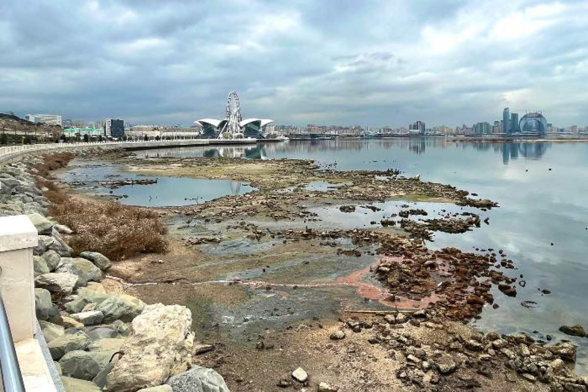
Caspian Sea recedes 150 km along the Kazakhstan coast and 20 km along the Azerbaijan coast
Over the past thirty years, the level changes in the Caspian Sea have significantly altered the region's ecological and geographical landscape. As a result of assessing the impacts of these changes, it has been found that the area of dried-up seawater zones along various parts of the Caspian coastline is 33,823 km². The greatest shoreline retreat of 150 km has been recorded along the Kazakhstan coast. Along the coastline of Azerbaijan, seawater receding has been observed at a distance of 20 km (Kizilaghac Reserve).

Area of dried-up lands by countries
According to calculations made by NASA based on satellite data from 1992 to 2024, it is seen that the Caspian Sea level has decreased by up to 2 meters. In December 2024, the level was -28.7 meters.

Changes in average level of the Caspian Sea based on satellite data
Observations and analyses carried out in the area, as well as the assessments and monitoring by "Azərkosmos," lead to the conclusion that the underlying cause of the recent shallowing process in the Caspian Sea is the sharp decrease in the volume of water discharged from the Volga River into the sea. The solution to the problem must begin with addressing this factor.