


Baku. Aynur Veliyeva - APA-Economics. The United Nations Office for Outer Space Affairs (UNOOSA) is holding a five-day International Workshop on the Applications of Global Navigation Satellite Systems.
According to its programme, the event officially titled “United Nations/Azerbaijan/European Space Agency/United States of America Workshop on the applications of GNSS is addressing, inter alia, the space technology applications such as: remote sensing, precision agriculture, aviation, transport and communications, and e-learning. The workshop aims at initiating pilot projects and strengthening the networking in the region. This workshop will also address the areas of natural resources management and environmental monitoring by applying GNSS technologies to thematic mapping, forest management and water resources management.
The programme includes plenary sessions and sufficient time for discussions among participants to identify the priority areas where pilot projects should be launched and examine possible partnerships that could be established.
Workshop is planned for a total of 80 participants including policymakers, decision makers and senior experts from the following groups: international, regional, national and local institutions, research and academic institutions, multi-lateral and bi-lateral development agencies, non-governmental organizations, and also from industry.
Azerbaijan’s Minister of Communications and Information Technologies Ali Abbasov said participants from more than 32 countries were invited to the event.
According to him, the participants are discussing the opening of a global navigation system regional center in Azerbaijan.
There is a remarkable and growing number of civil users of global navigation satellite
systems (GNSS) such as the United States of America Global Positioning System (GPS), the Russian Federation Global Navigation Satellite System (GLONASS), the European Galileo system and the Chinese Compass/BeiDou and a growing number of satellites augmenting existing GNSS constellations, such as GPS and Geostationary Augmented Navigation System (GAGAN/IRNSS) of India, and Quasi-Zenith Satellite System (QZSS/MSAS) of Japan. For developing countries in particular, GNSS applications offer a cost-effective way of pursuing economic growth without compromising the need to preserve the environment, thus promoting sustainable development. Satellite navigation is now used in a wide range of sectors, including but not limited to, mapping and surveying, monitoring of the environment, precision agriculture and natural resources management, disaster warning and emergency response, aviation, and maritime and land transportation.
Azerbaijan hosts International Workshop on the Applications of Global Navigation Satellite Systems

Infrastructure

Azerbaijan Railways plans to purchase new rolling stock from Chinese companies-PHOTO

Azerbaijan Railways showcases Azerbaijan’s transit and logistics potential at Transport Logistic China 2026

AZAL’s first Airbus A321neo delivered in Hamburg - PHOTO
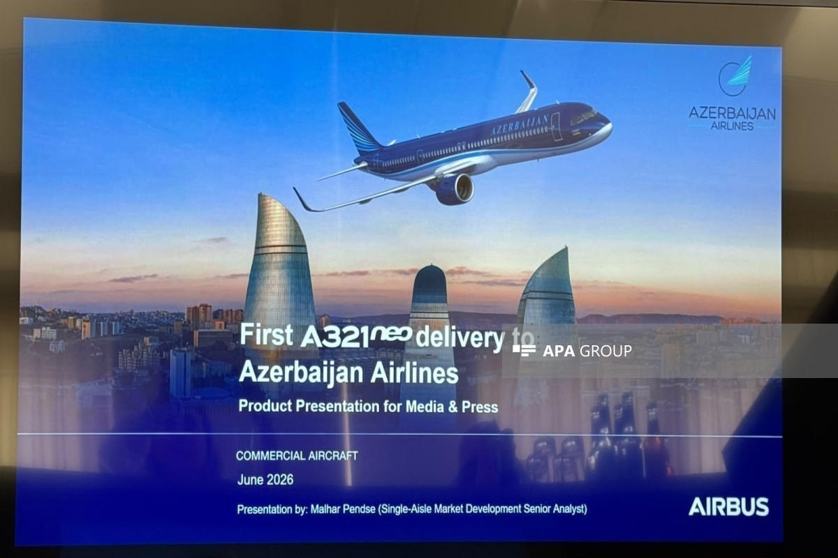
AZAL: New Airbus A321neo can be safely operated on any route - VIDEO
NEWS FEED
Von der Leyen announces first payment to Ukraine under €90 billion loan
Israel, Lebanon deny that Israel has withdrawn from part of southern Lebanon
Armenian PM says no Cabinet reshuffle planned
Azerbaijan Railways plans to purchase new rolling stock from Chinese companies-PHOTO
Pashinyan questions EAEU partners over statement adopted in Armenia's absence
New resolution, old approach: PACE's bias against Azerbaijan continues - ANALYSIS
Iraq to consider all options if OPEC quota is not raised, has weighed exit, sources say
Ali Asadov meets with Astrakhan Region Vice Governor
Syrian MP: We hope Turkmen students will have the opportunity to study in Azerbaijan
Iraqi MP proposes representation for Turks living abroad within Organization of Turkic States
180 people from 44 families return to Khankendi, Khojaly and Aghdara - PHOTO
Ashura blood donation campaign continues, 765.45 liters of blood collected-UPDATED-PHOTO
Bishop of Baku and Azerbaijan: Religious organizations in Azerbaijan demonstrate unique unity
Azerbaijan to host first FIFA U-15 Boys’ World Cup and 2026 Festival
20th Session of PUIC Conference concludes - UPDATED
Samad Seyidov: PACE resolution is biased, this piece of paper has no significance
IRGC threatens to target ships using new Hormuz route that forgoes Iran coordination
Religious leaders join Ashura blood donation campaign in Azerbaijan - PHOTO
President Ilham Aliyev congratulates Slovenian President on Statehood Day
Baku Steel Company Represented at the 5th Tashkent International Investment Forum
Citynet has been refreshed – now even more convenient for everyone
486 donors participate in Ashura blood donation campaign so far
Azerbaijan determines procedure for foreign individuals and legal entities to use its aquatic bioresources
New sales rules proposed for fisheries products in Azerbaijan
Azerbaijan drafts new law to modernize fisheries sector
Private sector to be involved in production of original and elite seeds in Azerbaijan
Azerbaijan proposes new state fees for seed operator registration and certification
Azerbaijan prepares new draft law "On Seed Production", establishes registry
U.S. Congress hosts conference on ethnic cleansing of Azerbaijanis in Armenia - PHOTO
Azerbaijani Azeri Light crude oil price declines on global markets
Trump says US ready to help Venezuela after major earthquakes
At least 32 killed in Venezuela earthquake - UPDATED - VIDEO
Azerbaijan sends next resettlement convoy to Khankendi, Khojavand, Shusha, Jabrayil and Aghdara
Trump says Erdogan is the reason he's attending NATO summit in Türkiye
US seeks $672 million for removal of Iranian uranium, nuclear inspections
Trump: Iran imposing fees on Hormuz would block deal with US
Qatar out of World Cup after losing 3-1 to Bosnia
Switzerland beats Canada 2-1 to win World Cup Group B
European allies let US down during Iran conflict, Trump says
Today marks Ashura in Azerbaijan
Lent.az marks its 18th anniversary
Trump says Iran making 'very big' concessions
Iran blames US for regional instability
Rubio: Upcoming technical talks with Iran will be at expert level, start June 30
Zelenskyy says drone signal repeaters in Belarus have been switched off
US Treasury Department has removed seven individuals and two vessels from sanctions lists against Russia
Araghchi discusses US talks with Saudi foreign minister
Ghalibaf: Azerbaijan-Iran relations have seen greater development over the past year
Sahiba Gafarova meets Speaker of Iran's Parliament
Meeting held with delegation from Pakistan National Defense University